File:Map of Greater Serbia (in Yugoslavia)-pt.svg
Jump to navigation
Jump to search

Size of this PNG preview of this SVG file: 709 × 600 pixels. Other resolutions: 284 × 240 pixels | 568 × 480 pixels | 908 × 768 pixels | 1,211 × 1,024 pixels | 2,422 × 2,048 pixels | 1,283 × 1,085 pixels.
Original file (SVG file, nominally 1,283 × 1,085 pixels, file size: 265 KB)
Captions
Captions
Add a one-line explanation of what this file represents
Summary[edit]
-pt.svg&action=edit§ion=1)
| Description |
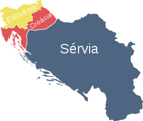
Português: Grande Sérvia, Croácia e Eslovênia no interior da Iugoslávia |
| Date | |
| Source |
This file was derived from: Map of Greater Serbia (in Yugoslavia).svg: |
| Author | Дмитрий-5-Аверин (talk · contribs) |
| SVG development |
.svg)
Licensing[edit]
-pt.svg&action=edit§ion=2)
This file is licensed under the Creative Commons Attribution 3.0 Unported license.
- You are free:
- to share – to copy, distribute and transmit the work
- to remix – to adapt the work
- Under the following conditions:
- attribution – You must give appropriate credit, provide a link to the license, and indicate if changes were made. You may do so in any reasonable manner, but not in any way that suggests the licensor endorses you or your use.
File history
Click on a date/time to view the file as it appeared at that time.
| Date/Time | Thumbnail | Dimensions | User | Comment | |
|---|---|---|---|---|---|
| current | 02:26, 29 July 2017 | | 1,283 × 1,085 (265 KB) | Renato de Carvalho Ferreira (talk | contribs) | User created page with UploadWizard |
You cannot overwrite this file.
File usage on Commons
The following 6 pages use this file:
_hr.svg)
_sr.svg)
File usage on other wikis
The following other wikis use this file:
- Usage on gl.wikipedia.org
- Usage on pt.wikipedia.org
-pt.svg&oldid=746086828)